Eureka Mining alluvial mine : Alaska
I have been invited to study surface mining at the MB Mining Inc. mine site. MB Mining Inc. is currently working in the Manley Hot Springs Eureka Mining district. MB Mining Inc. utilize methods of alluvial gold recovery that maximize yield, whilst reducing overheads and maintain an accredited reclamation project for the work site environment and eco system.
Site Management Tools Developement
|
Toolsets that allow the end user to efficiently make :
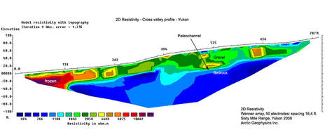
Using LiDAR ( Light Detection And Ranging) technology and drones allows efficient survey of mining claims to future proof the lifetime of the mining enterprise. Coupling this survey technology with UI designed to manage the site, over its working life is the end goal. An affordable, easy to use interface, with the ability to update the topography at will. Utility of the latest technological data gathering services, mitigates potential site mismanagement, and maximizes site profit. |
|
LiDAR and Drones
Light Detection and Ranging (LiDAR) sensors use light energy, emitted from a laser, to scan the ground and measure variable distances. The end result is a rich set of elevation data that can be used to produce high-resolution maps and 3D models of natural and man-made objects.
Compared to other aerial survey methods, drone-based LiDAR collection yields the highest fidelity data. The point cloud generated from drone-based LiDAR can yield 100–500 points per square meter at a vertical elevation accuracy of 2–3 centimeters.
Compared to other aerial survey methods, drone-based LiDAR collection yields the highest fidelity data. The point cloud generated from drone-based LiDAR can yield 100–500 points per square meter at a vertical elevation accuracy of 2–3 centimeters.
For more information regarding the site please visit us http://www.mbmininginc.com/
